


For our annual summer mountain activity, we decided to do a 3-day hike in Massif de Belledonne. The hiking route was based on the itinerary from Loomi, an application that facilities the planning of outdoor adventures. If we were to follow the route, we would cover 34km / 2400m altitude gain. The route was rated as difficult. However, looking at the daily mileage, it seemed doable based on our experience.
Massif de Belledonne stretches 70km long and 20km wide. It forms part of the French Alpes mountains which are in the southeastern part of the country. The 34 km hike constitutes part of the GR 738. GR or Grande Randonnée is a network of hiking trails that guide hikers in their exploration of the French landscapes. We have often used the GR in our trail runs and our hikes. Not all the GRs run through mountains. When we lived in the Parisian region, we did some GRs which were easier with no significant ascents. The last time we used the GR was last year when we did GR91 (crossing the Vercors Plateau).
GR738 crosses 2 French departments (Savoie and Isère – where I live) and stretches to just under 130km. Our itinerary was limited to within Isère. According to the Loomis itinerary, the split of the mileage is as follows. Based on our hiking experience, the itinerary is not especially hard and we usually move faster than the estimated pace of average hikers.
It is true that arrogance does bring downfall. Perhaps it was the decline of my overall fitness (especially after a 2-month stay in Singapore). Or perhaps it was due to my lingering cough and runny nose that I had for the past 2 weeks before the hike. Or maybe the time estimation from Loomis was too optimistic. The 3-day hike was much harder than expected. Below showed what we did over three days (per Strava records)
Our GPS recordings and that of Loomis were quite different. The difference in distance could be attributed to the different GPS devices used. However, their pace estimation for Day 2 seemed to be very optimistic.
For Day 1, we didn’t camp at Refuge de la Pra (a mountain shelter), Loomis’ suggested camping site. Instead, we camped a little further. This was because it wasn’t even 3pm when we reached the mountain shelter (we took 4h 15 minutes). We decided to continue a little more to camp at a spot just after the next hill. Hiking a bit more on Day 1 meant that we could do less on the second day. As such, we went over Col de la Pra, descended and camped after the next lake (Lac du Crozet).
Since the extra distance we covered on Day 1 was part of the route on Day 2, logically it meant that we would have a shorter distance / time to cover on the following day. Yet, on Day 2, we spent 11 hours on our feet, much longer than Loomis’ estimated time of 9 hours. One would think that our fitness level was in question. However, our pace was aligned with the time estimation posted on the various signposts along the route. That implies that we were not slower than an average hiker.
For this hike, each of us carried 3 litres of water. In retrospect, we could significantly lighten our load by carrying less water as there were streams along the route and a water source at each refuge. The main reason we carried 3 litres was the perpetual uncertainty of water source. There might be streams in one year, and these same streams might dry up the following year. This was what happened to us last year when we hiked at the Vercors Plateau during a heatwave.
On Day 3, our aching bodies and tormented minds couldn’t stand doing anymore climbs. So, we took an early exit by avoiding Cime de la Jasse, another peak and descended directly to Prapoutel, the village where we would take a bus back to Grenoble. Our descent was mercifully gentle on our legs—neither steep nor technical.
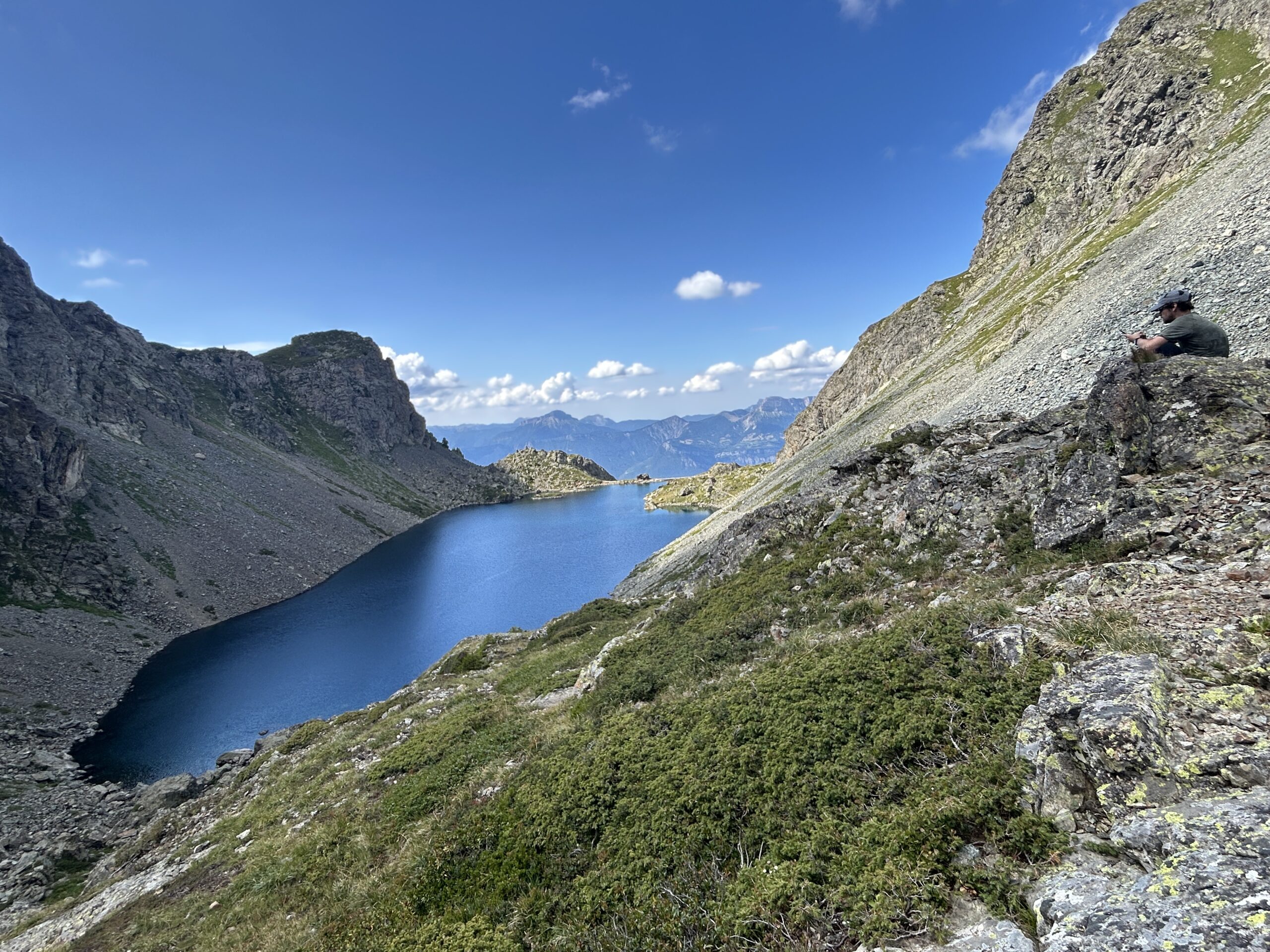
The main feature of Day 1 was the lakes along the route. We came across 3 lakes: Lacs Robert (made up of a cluster of 4 lakes), Lac Longet, Lac Claret, and Lac du Crozet. The lakes were all situated at an elevation of around 2,000m. As the saying goes, there’s no free lunch. To appreciate the bodies of turquoise blue waters, we always had a peak to ascend.
As mentioned above, we did not follow the itinerary closely. Instead of camping at the Refuge de la Pra on D1, we proceeded 1.5km further to Lac du Crozet, an infinity-pool like lake (profile photo). However, there was no flat ground next to it to set up our tent. We continued our hike for 1 more km and found ourselves a flat grassy corner. It was the perfect spot as there was a small running stream next to it and best of all, it was unoccupied!
We were not alone for long. Right after our dinner, we had a surprise visit—while wild mountain goats (bouquetin). In the beginning, there was only one goat. It appeared out of nowhere, standing on the rock 2 metres away from our tent. It gazed at me unflinchingly, seemingly unafraid of human beings. I whispered to my husband that we were very lucky to experience having a mountain goat so close to us. I have seen mountain goats before, but never have they been so physically close to me. They are always far up in the mountains, standing on treacherous rocks.
I spoke too soon. Seconds after I took wonder in my good fortune, more wild mountain goats came running towards us. They were leaping down from the rocks of the nearby hill. These brown agile 4-legged creatures stopped short, three metres away from us. Close to ten of them. They had to be a family. They loitered around, grazing on the ground, looking at us nonchalantly. Some of them circled around our tent, but never came closer to us. At one point, I was afraid that they would invade the 3m space. One mountain goat was cute. 10 mountain goats became threatening!
As I stretched my legs in the sleeping bag under the tent, I could feel a layer of soreness flowing through my body—from my shoulders to the tip of my toes. The discomfort didn’t disappear after a 9-hour sleep. After a quick breakfast of instant coffee and chocolate / raspberry muesli for breakfast, we continued with the route. It was a tough day: 11 hours on the feet and about 1,500 m of elevation gain.
Not only was the distance longer on Day 2, there was also more elevation. Loomis estimation was 1,300m for Day 2. Since, we did extra distance on Day 1, which included an extra hill (Col de la Pra – 100m+), it meant that we should have about 100m less to climb on Day 2 (1,200m+). When I reached a total elevation accumulation of around 1,200m, my first reaction was relief. Relieved that most of the elevation had been done. However, when I lifted my eyes and saw another hill ahead of me to clamber over, I just wanted to cry.
Endless little hills to overcome, and some of them were quite steep. The climb to Refuge Jean Collet left an impression. It was only 1km to reach the shelter from the valley, but with a gradient of 25% (250). The worst part was that 210m of that elevation concentrated in the last 600m, making it a 35% sheer ascent.
Apart from the distance and the steepness, there was the rocks. Big rocks to clamber over with close to 10kg on one’s back. It was a balance act. Then of course, there was the steep descents scattered with loose stones that make one slip and fall one on the butt occasionally.
In the last two hours, my mind just shut down. The only thought in my mind was putting one foot in front another. Not looking up, but just at my feet. The weight on my shoulders seemed to have become heavier even though it wasn’t possible logically. My continuous sipping of water from my hydrate bag should have lightened my backpack.
These little difficulties I mentioned are part and parcel of hiking in the mountains. So, why do I subject myself to these discomforts year after year? Gratification. The gratification derived from knowing that I can overcome these challenges, mentally and physically. Knowing that makes me stronger.
This hike has taught us a few things. Or rather, it has reminded us of the things that we have already known but have not diligently put into practice.
We (or rather my husband) usually do the research by watching YouTube or reading up on the blogs of hikers who have done the same route. Their hike recordings could be used as a confirmation on third party’s estimated time and elevation measurements. In addition, the hikers might share insights on the route technicality or the availability of certain essentials (e.g. water sources, conditions of the shelters). Moreover, we should also map out the route ourselves instead of relying entirely on a third party’s estimation. This is to avoid significant differences in distance/elevation due to the usage of different GPS devices, and better manage our expectations.
Do not take for granted that we will always be in shape. My lingering coughing bouts and runny nose, and my inconsistent running routine during my two-month stay in Singapore have not helped my stamina. Moreover, since we are now living in Grenoble, we can easily take long weekends to go to for a 2-day or even 3-day hike. This will help to build up our fitness level.
Every extra gram that you carry in your backpack will weigh more with each step you take, especially during an ascent. Maybe not in the sense of actual weight, but you will feel like that gram has ballooned. My husband and I have been talking about changing our camping cooking set and our sleeping bags for the last few years but we have never gotten to doing it. I think it’s an unavoidable expense if we want to enjoy more of our hike. The sleeping bags that we have are thick and thus more suitable for late fall camping, not the hot summers we have in this region. As for the cooking set, it was on the low-price range and thus weighs quite a bit. In addition, frivolous things like flip flops (mine) and kindle (my husband’s) should have been left at home. Neither had been used during the hike.
Regardless of the physical and mental discomfort that we faced during the three days, we were glad to have done the hike in Massif de Belledonne. Other than discovering new landscapes, a more important reason for hiking is to challenge ourselves physically and mentally. I can say that both objectives have been achieved.