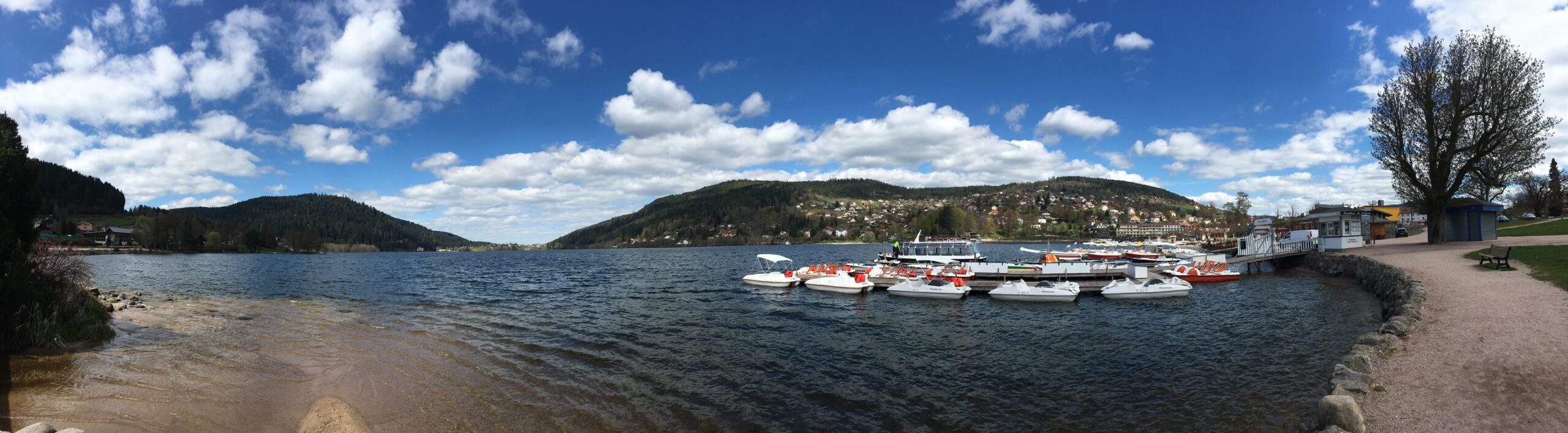
A panoramic view of Lac de Gérardmer under a clear blue sky.
On our last day in Gérardmer, we woke up with sun shining in a clear blue sky.

Trail Running in the Vosges Mountains

Trail running in the Vosges mountains! It was our first official holiday (25-29 April) since I settled in France at the end of February. Silviu, and I had planned our vacation since January. We wanted to jumpstart the spring season with a 5-day stay in Gérardmer at the end of April.

We were looking forward to shrugging off the cold grey season, and cruising on the trails in the coniferous forests, under the clear blue sky, in the crispy spring air. Our key race for this year is the 50 km OCC, a sister race of UTMB at the end of August, and we need hill training. Unfortunately, living in Île-de-France (a region in north-central France that encompasses the Paris region) makes long hill training hard. The hills here are generally less than 200 m, and the trails are mostly urban, with not much technicality. We were hoping that the stay in Gérardmer would let us catch up on some elevation training.

Hike Snapshot

A trail marker sign for mountain bike routes, attached to a tree trunk in the Vosges Mountains.

We covered 20 km in Day 1, starting from the trailhead next to the ski station, covering the 3 hills on the southern side of the lake, with a total elevation of 740 m/D+ (Moving/Elapsed time: 3h 17 minutes/4h 56 minutes). On Day 2, we covered 962 m/D+ over the 3 hills on the northern side of the lake (Moving/Elapsed time: 4h 42 minutes/6h 40 minutes) in 24 km. On our last day, we covered only one peak, and our highest peak in the 3 days, reaching a total elevation of 624 m/D+ over 20 km.

(Route 5 and 7 share certain sections of the trail. The brown sign above indicates one of the symbols used in the marking of mountain bike trails. Route 7 covers the immediate mountains surrounding Lake Gérardmer.)

Get to Gérardmer

Gérardmer is 440 km east of Paris. We took a TGV (France’s high-speed rail service) from Paris and reached Épinal, a neighbouring town of Gérardmer, in less than 2.5 hours. By the time we reached Épinal, the temperature had dropped to low single digits. When our bus dropped us at Gérardmer, situated at an altitude of 670 m, snow flurries lashed onto our faces.

A screenshot of the Météo-France weather forecast showing snow in Gérardmer, Vosges Mountains.
Forecast from the Météo-France, the official site of weather forecast in France. The forecast shows only the weather in the town. Going into the hills would be colder.

Looming Cold Snap

An escalating sense of foreboding crept into our happy warm images a week before our departure. The weather forecast showed temperatures plunging and even the possibility of snow during our 5-stay in Gérardmer.

A couple taking a selfie by the lake in Gérardmer, Vosges Mountains, with pedal boats moored behind them.
My nose was all runny and my fingers were numb from the taking off my scarf and gloves to take a photo of the lake.

Relentless Snow

After checking into the hotel, we braved the snow flurries, mixed with freezing rain, to have a quick glimpse of Lake Gérardmer, the largest lake in the Vosges and one born of glacial origin. After seeing the various photos of the lake advertised on the internet, it was disappointing to see a grey body of water, partially cloaked by the winter fog – the winter had tainted all the colours.

The snow flurries were relentless, and did not let up the rest of the day, nor for the next three days. The temperature in Gérardmer mostly remained around freezing point. A thin layer of snow covered the town centre.

Untested Winter Running Gear

One of the worries we had was whether the running gear that we brought with us was adequate for the weather. Neither of us had ever hiked or run in snow before, and so had never tested our gear in this type of inclement weather.

Struggle out of Warm Hotel Bed

It was indeed very hard to get ourselves out of the warm hotel bed. However, there was not much to do in the town, and our hotel room was too small to be cooped up in for days. We had also already spent a significant amount on travel expenses. So we decided to bite the bullet and brave the snow.

Station de Trail

In 2011, France first introduced the concept of Station de Trail, or a “Trail Station”, and the concept has spread to various parts of the country. Each station offers a range of services to outdoor enthusiasts, including well-marked trail routes, which indicate the level of difficulty, shower/changing room facilities for hikers/runners who passed by, and running workshops.

Colour Codes

On Day 1 and Day 2, we completed Route 7 of the Station de Trail in Gérardmer and we did parts of Route 6 on Day 3. Similar to the colour codes of ski slopes, the difficulty level of each route is reflected in the colour used to mark the trail. For instance, Route 7 is marked in red, indicating the most difficult level among the trail routes in the Vosges department.

Running Hopes Dashed

We abandoned any hope of running soon enough. Our progress was slow. From the trailhead to the first peak at 1,046 m, it took us 33 minutes to cover 150 m/D+ in 1.3 km, that is 2.4 km per hour! We were hampered by the thick pile of snow. At times, with each step I placed onto the snow, I would sink to my mid-shin. To extract myself, I had to lift my other leg as high up, before sinking down again into a fresh mound of snow.

Calf and Gluts Workout

Repeating this action over several hundred metres at any one time, and trying not to tumble over the more resistant snow piles, consumed too much energy. Coupling the thick snow with an uphill climb, it was one of the more effective calf and glute workouts I ever had!

Day 1 (26 April 2016)

The trailhead was 230 m higher and about 2.5 km away from the town centre. Certain steep sections of the first 2.5 km already generated enough heat for me that I had to remove my beanie and the first layer of long-sleeved Icebreaker by the time I reached the trailhead.

Diluting an energy drink with fresh snow during a trail run in the Vosges Mountains.
One of the advantages of the plentiful fresh snow: Diluting the sweet Tailwind energy drink with snow.
A snow-covered trail in the Vosges Mountains, with a hiker walking through the winter landscape.
Walking towards the Trailhead. Winter wonderland.

A different scene was presented to us when we reached the trail head (ski station). The ski slope was entirely covered in two inches of snow, a scene befitting a ski resort in the WINTER, not the end of April! A signage at the start indicated the temperature to be 0°C. There was hardly anyone around, and the whole ski station, including the restaurants, had closed for the day. We passed two teenagers, one of them holding a large red circular sledge, walking up the slopes.

During our descents in certain parts of the forest, we caught a glimpse of what the trails could be like in nicer weather. They were very runnable, with sections where one could happily cruise along, surrounded by lush coniferous trees.

A forest trail dusted with light snow in the Vosges Mountains.
Glimpse of the Spring’s greener vegetation.

Invisible Obstacles

There were, however, also sections of the trails that were scattered with rocks and thick roots. These obstacles were hardly visible, as patches of snow covered many of them. We had to mind where our feet were placed, as any inadvertent quick movement from us might mean a slip and a fall.

Sliding on My Butt

It was harder during descents, for instance, the last descent on Day 1, we had to cover a drop of 200 m/D- in 1 km, on technical trails. At times, I was on my butt, sliding down the trails grabbing the nearby plants.

Day 2 (27 April 2016)

We were apprehensive of how our legs would react after yesterday’s 20 km of unaccustomed activity. Wanting to save some energy for today and Thursday too, we decided to start gently, fast-walking the 3.1 km around the lake to the base of the first climb.

The view from Roche Morand over the snow-covered Vosges Mountains.
View from Roche Morand, a stop at 910m, just before the peak of the first climb of Day 2.

First Climb

The first climb would take us to our 2nd highest peak today, standing at 943 m. The trail started with some steps, before turning into a long mountain road covered with snow. The snow must have continued throughout last night to this morning, as certain sections of the mountain road were piled high with powdery snow.

Second Climb

Panoramic view from Roche de Bruyères over the snowy Vosges Mountains landscape.
View from Roche de Bruyères, a stop at 919m.

By the time we started with the 2nd climb, it was already slightly past noon. The lower altitude of 633 m and the slightly higher temperature at noon had melted much of the snow. The lush green vegetation, which one would expect in spring, revealed itself amidst the slush. Instead of the thick snow, we had to pay attention now to where we placed our feet to avoid the puddles of slush.

The first part of the 2nd climb was steep, but was eased by a few small switchbacks. We covered 134 m/D+ in 767 m, approximating 19% in gradient. The second part of the climb took us up to Roche de Bruyères, at 919 m, where a view of Gérardmer and its lake could be admired. The cloudy sky did not do justice to the blue waters of the lake. However, set against the winter grey, the city and its lake revealed a different side of beauty.

Third Climb

The third climb of the day took us to a high of 1,044 m, and this was the section where most of the snow trudge took place. By the time we commenced this ascent, we had already covered 15 km and tiredness was already seeping in. We estimated that we had dredged our legs through at least 5 km of 20cm-deep snow mounds.

Descent

In our last descent, we had to cut across two ski slopes. Always feeling slightly vertiginous at heights, walking across the slopes and trying not to trip and slide down the ski slope already made me nervous. Unable to tear my sight from the plunging view of the Gérardmer valley, I felt even more high-strung during the crossing.

By the time we reached the La Mauselaine ski-station (where we started our run on Day 1), it was close to 5.30 pm. The sun was still around, casting a ray of warmth on us. To get to the city centre was another 1.5 km of downhill, mostly on road, mixed with some short steep sections of trails. Just 50 m above the city centre, at the view point of Roche du Rain, we finally caught Lake Gérardmer again — for the first time in two days, cloaked in its resplendent blue under a clear sky. [Refer to the main feature photo]

A person making a snow angel while lying in fresh snow during a trail running trip in the Vosges Mountains.
Spring angel in the snow. Just having a little fun to forget the physical tiredness.

Day 3 (28 April 2016)

The moment that I woke up, I could feel the general tiredness in the lower half of my body. Today was the last day of our exploration of the Vosges Mountains. We planned to explore the hills on the eastern side of Lac de Gérardmer, which would allow us to visit two more lakes.

Lac de Lispach, a lake surrounded by snow-covered forest in the Vosges Mountains.
View of the first lake, Lac de Lispach.
Panoramic view from La Tête de Grouvelin over a lake and hills in the Vosges Mountains.
Panorama view of La Tête de Grouvelin.

The Climb

Similar to Day 1, our route would start from climbing from the city centre to the ski station of La Mauselaine. The climb to the first lake, Lac de Lispach, was the biggest climb in the last 3 days – a nonstop climb for more than 500 m in 6 km. The first climb wasn’t as steep as the others, but it was still hard — the forecasted improvement in weather never came through. It was a long, tough trudge up to the peak of La Tête de Grouvelin at 1,140 m.

To Lac de Longemer

To get to Lac de Longemer, the second lake, we first had to walk on short sections of raised half-a-metre wide wooden walk boards (alternatively, on the muddy patches). The boards were covered with snow that had refrozen (and thus slippery). We then traversed on a narrow trail that was covered with one to two inches of snow, that cut across the face of the slope.

If one tripped and slipped on the snow, or placed a foothold on a pile of snow mistaken for solid trail, it was easy to tumble down the slope. It wasn’t too steep or deep (about 10 m), but it was strewn with rocks. At certain sections, iron rods helped us cross from one precarious part to another. After safely cutting across the face, the descent was short, but steep, over rocky terrain, mostly covered with wet snow. I spent most of the descent on my butt, sliding down slippery, muddy rocks, mixed with snow patches.

The forest gallery displays pictures along the way. A walk in the nature art gallery.

Early Exit

By the time we reached the road, next to the 2nd lake, we had already covered 13 km and more than 600 m/D+ in 4h. We decided to call it a day and abandon the initial plan to climb the second hill, which would take us directly back to the city. Instead, we just walked 6 km on the paved road back to Gérardmer.

Turn Adversity into Opportunity

64 km, 2,326 m/D+ in 3 days. The unexpected adverse weather conditions threw our running plans in the Vosges astray. Under normal circumstances, we would never have entertained the idea of trudging through inches of snow in the mountains. However, the adverse weather conditions gave us the opportunity to realise that we are physically and mentally strong enough to undertake such a feat. It also shows us a different side of the mountains that we usually enjoy within the warmth of a car or the four walls.

Guess what. On our last day in Gérardmer, we woke up with sun shining in a clear blue sky, temperature mid-teens, and we couldn’t see a trace of snow in the town.

Leave a Reply

Your email address will not be published. Required fields are marked *